WingsLevel turns your phone into an attitude indicator with speed, altitude and vertical-speed
tapes, and an HSI with Direct-To navigation. Its GPS-aided attitude stays true in turns,
where ordinary phone apps drift back to wings-level.
Built for the cockpit: large, readable instruments, night mode, and nothing to
configure before engine start.
Attitude indicator
Pitch ladder, bank scale and aircraft symbol, with a turn indicator (wing tip on the mark
= standard-rate turn) and a slip ball that stays centred in a coordinated turn, even with the
phone slightly rolled in its mount. Full-screen mode with a heading tape. If the phone's sensors ever stop, a red X replaces
the horizon at once: it never shows a frozen attitude as if it were live.
Speed, altitude & VSI tapes
Ground speed, altitude and a smooth vertical-speed indicator from GPS combined with the
phone's accelerometer. Red flags when GPS is poor or stale.
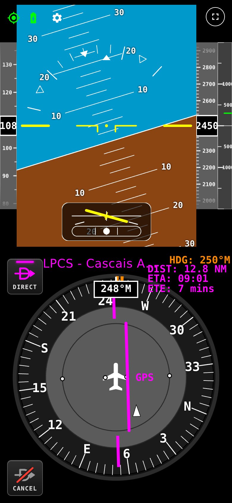
HSI with Direct-To
Magnetic compass rose, like your compass, charts and ATC, with heading bug, bearing pointer and
a GPS course-deviation bar with TO/FROM. Distance, ETA and ETE at a glance.
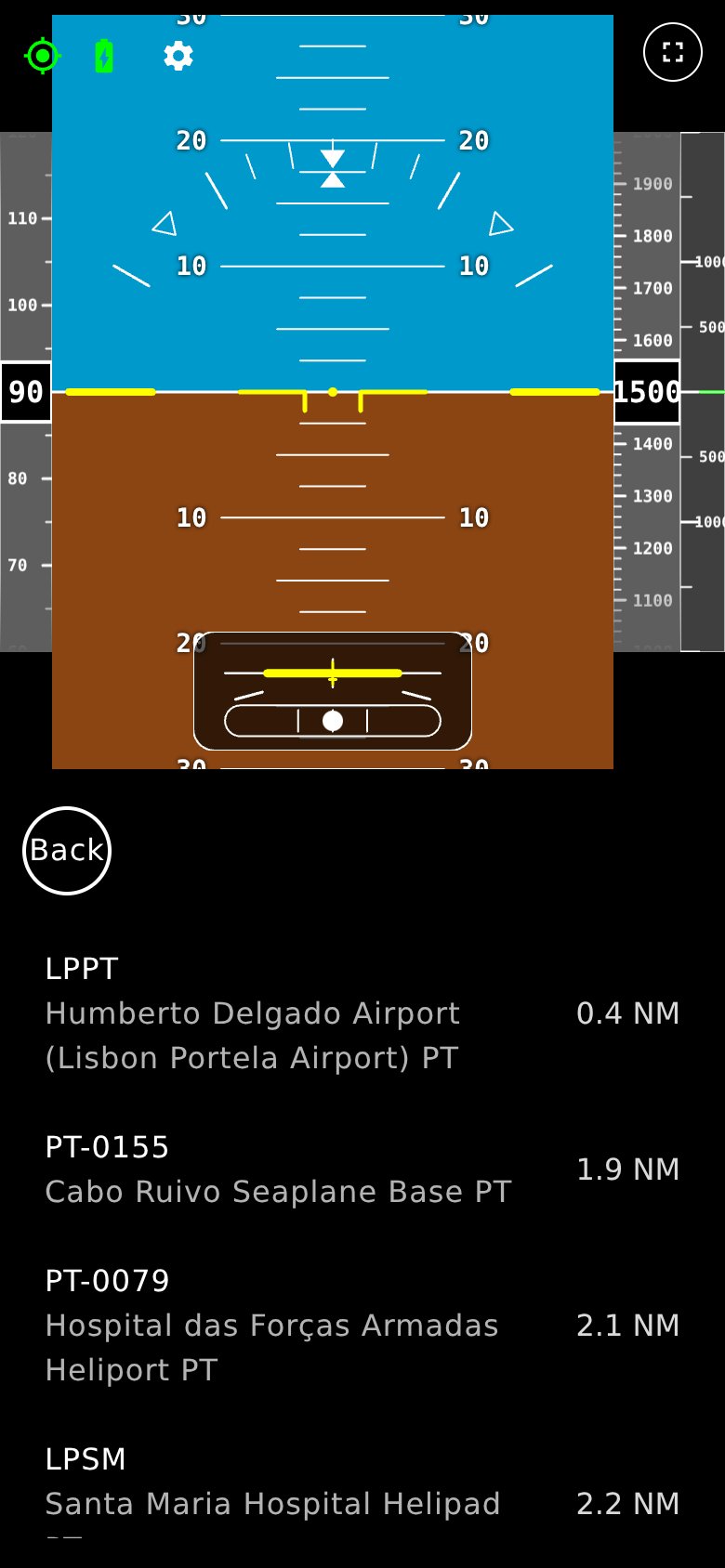
Nearest & search
Nearest airports and navaids by true distance from your GPS position, anywhere in the world,
or search by ICAO code and country. Runways, surfaces and frequencies for every airport.
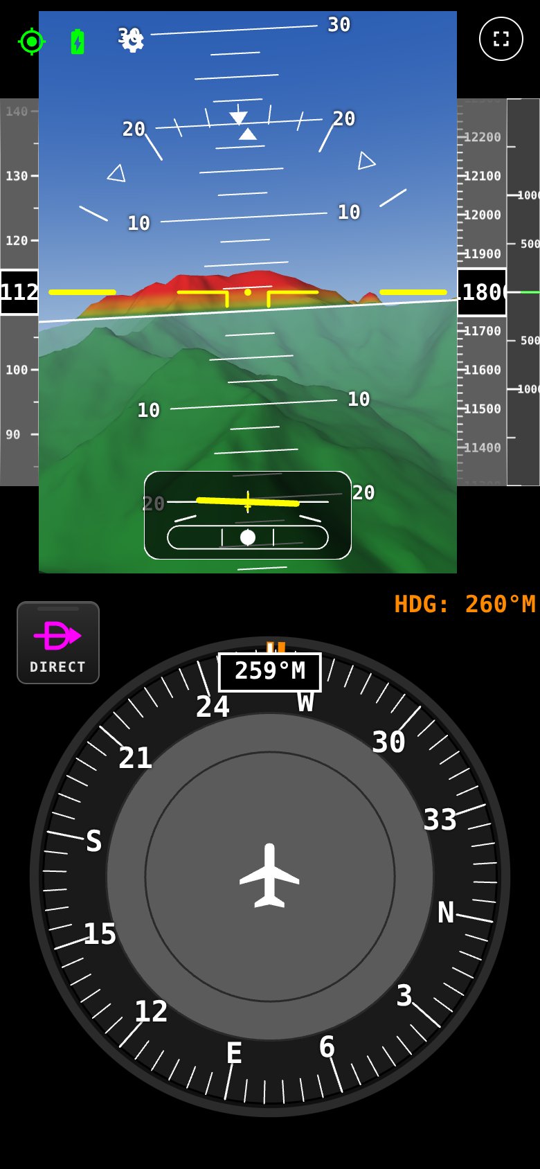
Synthetic vision
3D terrain of the whole world behind the horizon, coloured by height above you, with lakes
and sea, runways and markings, and detailed 90 m terrain in the mountains. Download the areas
you fly in once and it works with no connection.
Night mode
One tap turns every instrument red-on-black to protect your night vision.
Mount it your way
Level removes any tilt of your mount on the ground (in flight only when you fly straight
and level, so a turn is never stored as level), and the app learns by itself if the phone points
slightly left or right of the nose, on the takeoff roll.
Flight recorder
Record raw sensor and GPS data and export it after the flight, to review or share.
No app store needed
Installs from your browser like an app, full screen, keeps the screen on, and updates
itself when you are online.
Why phone attitude apps lie in turns
A phone's accelerometer can't tell gravity from the aircraft's own acceleration. In a coordinated
turn, the force you feel points straight "down the seat", so an ordinary phone app slowly
decides the wings are level while you are still banked. The same happens in pitch on the
takeoff roll or when you add power.
WingsLevel runs a GPS-aided Kalman filter, the technique used in real
inertial navigation systems. It compares what the accelerometer measured with how the GPS
says the aircraft actually moved, so it knows how much of the force is turning and
accelerating, and keeps the horizon where it belongs.
In a sustained 30° turnPhone-only appWingsLevel
Bank shown after 90 sdrifts toward 0°30° ± 2°
Pitch on the takeoff rollfalse nose-upstays level
Phone not aligned with the nosebank reads as pitchlearned automatically
Without GPSstandard behaviourgyro coasts, then standard
Figures from the filter's flight simulation tests. Real-world performance depends
on the phone and the mounting.
See it in action
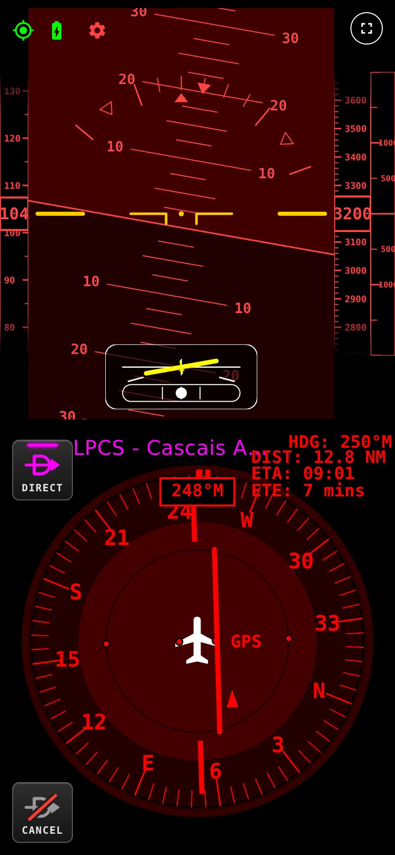
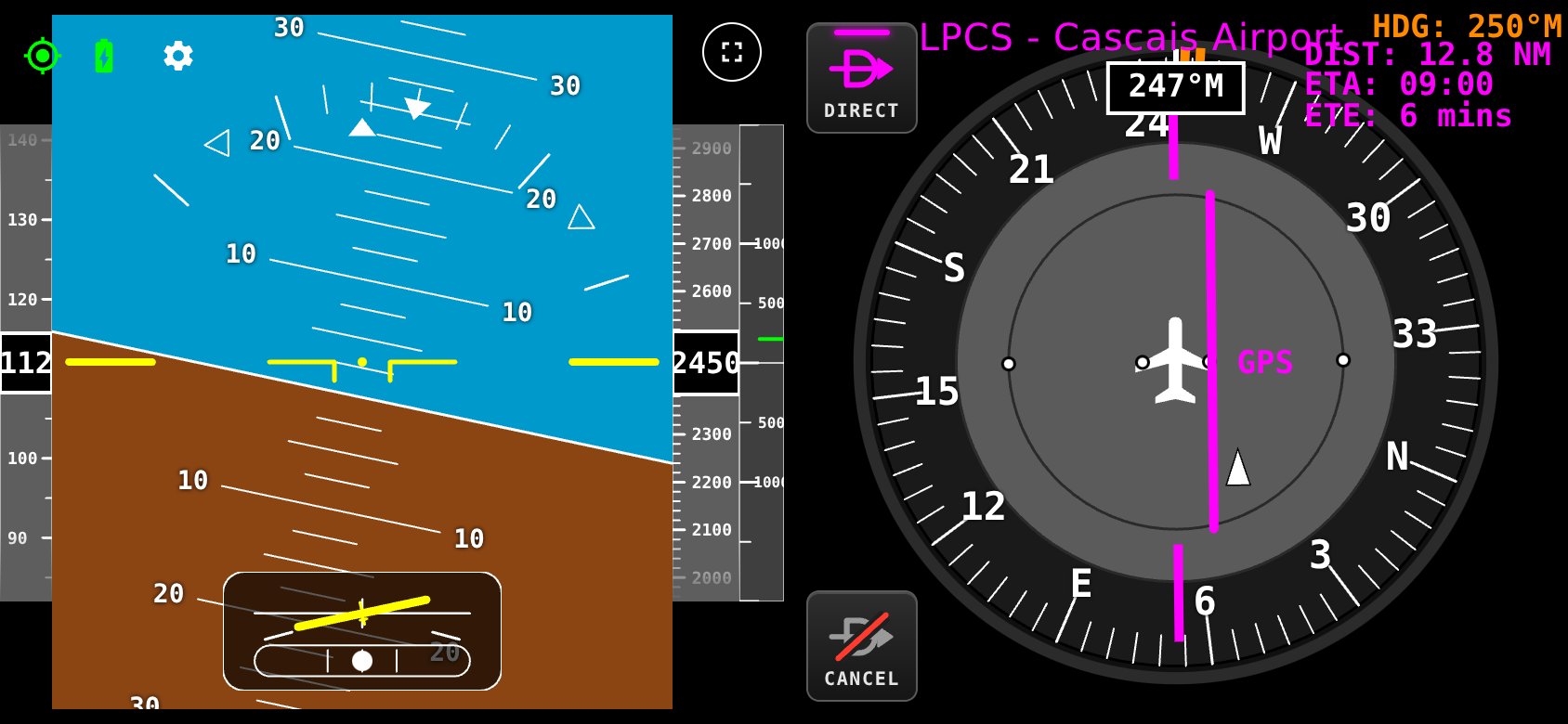
Portrait or landscape, day or night. These are real screens from the app.
Direct-To with course deviation
Synthetic vision: high ground in red
Nearest airports
Night mode
Landscape: attitude and HSI side by side, great for tablets and yoke mounts
Open the app on your phone and tap Install app (Android) or
Add to Home Screen (iPhone). It opens full screen, like any other app.
Download your areas
While on Wi-Fi, download the terrain for the areas you fly in from the Terrain Manager, so synthetic
vision works with no connection.
Mount, level, fly
Mount the phone upright facing you, tap Level on the ground, and go. No signal
needed in the air.
What you need
Android 10 or newer with Chrome and a gyroscope (most phones since 2018). Recommended.
iPhone with iOS 16.4 or newer (Safari).
A sturdy mount that holds the phone upright and a charging cable for long flights.
Questions pilots ask
Is WingsLevel certified? Can I fly IFR with it?
No. WingsLevel is not a certified instrument and must not be used for primary navigation or in
instrument meteorological conditions. It is a situational-awareness aid for VFR flight.
Always cross-check with your aircraft's instruments and look outside.
Does it work without mobile signal?
Yes. Once installed, everything runs on the phone: instruments, airports and navaids, and synthetic
vision (after you download the terrain for the areas you fly in). GPS works everywhere; it doesn't
need mobile data.
Where does synthetic vision work, and how much space does it need?
It works everywhere: the terrain covers the whole world, including the US, Canada, Australia, New Zealand,
the UK and all of Europe. You only keep the areas you choose on your phone: most countries take a
few MB to a few tens of MB, and the detailed 90 m terrain for mountain areas such as the Alps adds
up to a few hundred MB. Add or remove areas at any time in the Terrain Manager.
How accurate is it?
The attitude filter holds bank within a couple of degrees in sustained turns in our simulations, and
learns your mount's alignment by itself. Real accuracy depends on your phone's sensors and a
solid mount: recent phones from the main brands work best. Speed and altitude come from GPS,
so they are ground speed and GPS altitude, not airspeed or pressure altitude.
What happens if a sensor or the GPS stops working?
You see it straight away. If the motion sensors stop, a red X replaces the attitude and the HSI
shows a flag. If the GPS is lost or too imprecise (for example a phone falling back to mobile
network positioning), the speed and altitude tapes show a red X instead of old values, and the
map position is not moved by inaccurate fixes.
Which phone should I use?
Android with Chrome is recommended and gives the best sensor access. iPhones work through Safari.
Check it on your own phone and in your own aircraft before you rely on it.
Can I use it on my phone and my tablet?
Yes. Install it on each device you want to use, and download the terrain areas on each.
What happens to my data?
Your position and sensor data never leave the phone. There is no tracking in the app.
Safety notice. WingsLevel is a non-certified situational-awareness aid. It is not approved by
EASA, the FAA or any other authority, must not be used for primary navigation or IFR flight, and
consumer phone sensors can drift or fail. Always maintain visual reference and cross-check with the
aircraft's instruments. The pilot in command remains responsible for the safe conduct of the flight.